Three observations from the the historical toponimics of Ukraine
Tetiana Gedz
The article consists of three parts, each of which deals with the interesting topographical details found on maps of different periods.
Part one of the article speaks about the hydronym Dlsna, mentioned in the "Descriptio veteris et novae Poloniae" ("Description of the old and the new Poland") by S. Sarnitsky, 1585. On the basis of legends about the rivalry between the Dnieper and Desna rivers, recorded in southern Ukraine at the end of XIX century, was advanced the hypothesis that Dlsna is a written distortion of Desna – name of the left-bank tributary of the Dnieper river, which later was replaced by the name of Tatar origin Ilkysu (Konka, Konskiye wody). This hypothesis agrees with the assumption by D. Virsky, translator and researcher of "Description…”, that in the middle and lower course of Dnieper in the second half of the XVI century the traces of Slavic toponymy yet were fixed.
The second part of the article is devoted to the place names of different times indicated on the north-west of Kiev on the map made in 1912-1916. One of them is the trace of now disappeared lake Gallo, historical information about it containes in the works by L. Pohilevich. Second toponym belongs to the beginning of the XX century. It is a vast dacha settlement called “Dachy Chary” (“Enchantment Villas”), which was located about 100 km. from Kiev and 8 km. from the nearest railway station. Name, size and distance from Kiev distinguish it from the other dacha settlements that have emerged at the same time.
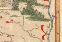
In the third part of the article reviewed the image area between the Dnieper and Ingulets rivers on the map of Poland by Ricci Zannoni, 1772. It is the only map shows the geographical names of a special type – "skok" (“jump”). So called the shortest distance along the ridge the watershed between the sources of small rivers flowing in opposite directions: to Dnieper and Ingulets. The presence of such names on the map indicates the use in the second half of XVIII century of routes along the rivers, both large and small. The name "skok" could come from the people of New Serbia, becouse in some Slavic languages (including Serbian and Croatian) this word means the passage of water across the different heights: a waterfall, or water “threshold”. From indication of a “threshold” on water this word could pass to indication of a "threshold "on land.
Full text in ukrainian language.

