Crimea on the map of South Sarmatia by Bernard Wapowski
Tetiana Gedz
The purpose of the present article is publication and analysis of the content of the map of the Crimea, practically unknown in Ukraine, which is a part of the map of the South Sarmatia of 1526 by “the father of the Polish Cartography” Bernard Wapowski.
Fragments of the map of the South Sarmatia were found in Poland in 1932 [1]. But history researches knew about existence and importance of this map as a source of representation of the Eastern Europe territory in the XVI – XVII centuries earlier. V. Kordt dedicated a small section to the maps by Wapowski [2]. F. Petrun created a table of “genesis” of representations of the territory of Ukraine by European cartographers from the first quarter of the XVI century to the first third of the XVII century, where exactly the maps by Wapowski are the starting point [3].
Modern researches of cartography history, namely R. Dashkevich [4], T. Liuta [5], R. Sossa [6], mentioned the map of the South Sarmatia 1956. But only T. Liuta paid special attention to toponyms marked on it in the characteristic of S. Munster’s map Polonia et Ungaria of 1540: “The map by S. Munster, comparing it with the map by Wapowski… represents the network of Tatar settlements at the border with Ukraine more thoroughly: Oslam, Precop , Coflo, Kerkel and others [7]”. As we shall see further, the Crimea on the map by Wapowski is represented with more details than on the map by Munster.
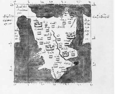
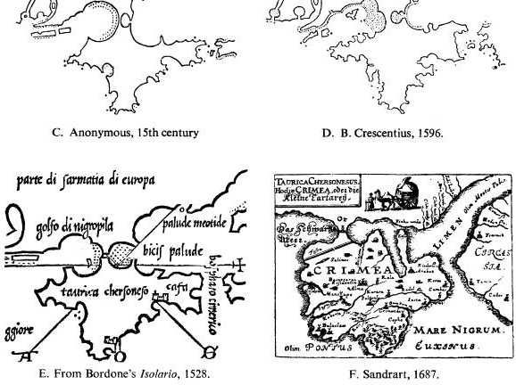
But before proceeding to consideration of the Crimea on the map by Wapowski let’s consider representation of the Crimea on the maps created by European cartographers before 1526. At present, there is no separate study on the evolution of historical maps of the Crimea. L. Bagrov’s addition to the article by H. Kohlin, in which a fragment of the Greek manuscript “The Geography” by Ptolemy, XIII century, which is kept in the Topkapi Palace Library in Istanbul, is indicated as the oldest map of the Crimea. The portolans of the XIV-XVI centuries and the “round” Crimea on the map by Y. Sandrart, 1687, [8] (Fig. 1, 2) are named by Bagrov as the next stages of mapping of the Crimea.
The publication of the collection of maps of the Azov and the Black Seas, which can trace the development and mapping of the Crimea, made by A. Gordeev [9] is worth mentioning. But description of the evolution of maps of the Crimea can be added and itemized, which is the purpose of the present article.
Maps representing the Crimea of the XIV – early XVI century can be divided into two groups: portolans and maps of the Ptolemy tradition.
Shapes of the coastline of the Black and Azov Seas and the Crimea are practically perfected on the sea nautical charts [10]. The particular attention is given to inhabited places on the coast, but representations of toponyms on the land are absent or schematic, except for especially big rivers and capitals. No settlement in the heart of the Crimean Peninsula was represented on portolans.

Fig. 1. Map of the Crimea from the Greek Manuscript “The Geography” by Ptolemy, XIII century.
Fig. 2. Evolution of Cartographic Representations of the Crimea by L. Bagrov.
The Black, Azov Seas and the Crimea have common characteristics on all maps made by the text description of “The Geography” by Ptolemy, starting from the map given by Bagrov to the maps published in the middle of the XVI century [11, 12]. The Crimea on them has a “triangular” (by Bagrov) form, the only river (Istrian) and settlements in accordance with the list and coordinates contained in the Chapter 6 of the Book III of “The Geography” are marked in its territory [13].
By the end of the XV century, maps of both groups (Ptolemy traditional and modern, and portolans) developed simultaneously, but as if in parallel worlds – their content and graphic peculiarities did not coincide, which was caused by different purposes of existence of both types of maps. The first attempt of such combination was made on the version of the map by M. Kuzansky, revised and supplemented by N. Hermanus and published in 1491 [14]. The names typical to portolans: Caffa, Soldea, Cimbab, Lemita, Dospera are marked on the characteristic “Ptolemy” outlines of the Crimea on this map. The Goths Principality with the capital of Theodoro and a settlement in the heart of the peninsula called Gzungari are marked only on this map. The first of these names fixed presence of the Goths in the Crimea and the second – Gzungari – probably is the only cartographic evidence of residence of Huns in the Crimea (Huns – Hungari – Gzungari). The map by Kuzansky-Hermanus can be considered as the most “modern” predecessor of representation of the Crimea on the map by Wapowski.
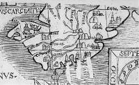
Let us consider the Crimea on the map by Wapowski (Fig. 3).
The peculiarities of this cartographic representation are the following:
– the original outline of the Crimea, nothing of its kind was met on any of European maps, at the same time the contours of the Black and Azov seas remain classic “Ptolemy’s”;
– the completeness of representation of the Crimea river system, unique for West-European cartography till the XVIII century. The main rivers of the Crimea: Salgyr (Salger fl.), Indol (Indal fl.), Tsuriuk-Su (Syrcu fl.), Black (without a name on the map), Belbek (Cubarta fl. – old name of the river [16]), Kacha (Casse fl.), Alma (without a name on the map) are marked. Such details sets even more wondering, if we take into consideration the fact that by the European standards, these rivers are not significant: “Belbek as well as Kacha, Alma and Salgyr are considered among the biggest rivers of the Crimean Peninsula, but in other countries, only large steams would be seen in them [17]”.
– toponymic net of settlements, which fully corresponds to its time. Land toponyms of the Crimea will be discussed in more details further.
Arabat (Arbath) is marked to the right of the mouth of the river of Tsuriuk-Su. Foundation of this fortress is dated to the middle of the XVII century according to Evliya Celebi [18]. But Arabat existed at the time of the Turkish conquest of the peninsula. “Turks, having seized Kaffa by force and arms, left behind not only this town and reinforced places Kerch, Enykale, Arabat, but also the entire Southern coast… [19]”. The mark on the map by Wapowski indicates of Arabat as a significant fortification in the early XVI century.
The notation of Kaffa (Cabha) is not new, since it was on portolans [20] and was mentioned by Miechowski [21] in the transcription Cafa, Caffa. In the Middle Ages, Sudak (Sudach) was better known in Europe under the names Suhdaia, Soldaia (Sodaia, Soldaya, Soldaja on portolans [22]), in Russia – under the name of Surozh. By Keppen, Sudak is the eastern version of the name [23].
Two previous names are well-known, which cannot be said about the toponym, located on the coast to the South of Sudak. It is read as Solsou. This word can be considered a foreign pronunciation of Suuk-Su (“cold water” in Tatar) – a fairly common Crimean hydronym. Then one can make two assumptions.
First. The river of the same name, near which the town of Sudak is located, is formed by the rivers Adzhybei and Suuk-Su. But the name Suuk-Su is sometimes applied to the whole river [24]. In this case, the part of the town of Sudak might be indicated as the separate town of Solsou.
Second. The settlement of the same name was located at the respective area of the Crimea to the South of Artek near the mouth of the small river Suuk-Su. Significant settlement in its place existed until the IX century, as evidenced by the archaeological research of the Suuk-Su burial [25]. In this case, the notation on the map by Wapowski gives grounds to talk about existence of the settlement with such name in the early XVI century.
The medieval town of Solkhat on the map of Wapowski is marked for the first time, and with the Tatar version of the name Crym. Mangup (Mancop), which completely lost its value as a town only after the fire in 1592 or 1593 [26], and Kerkel (Kerkel) as the main stake of the Crimean Khan at that time were marked on the map for the first time too, as evidenced by the sketch of worshiping the Khan depicted next to it.
The summer residence of the Crimean khans Alma (Alma) is also marked. Keppen mentioned the wooden defense Alma-Saray [27]. As the khan’s residence, it kept its value, at least in the second half of the XVI century [28]. Inkerman is marked by the name Inberne. The name Hezlevi (Coslo) is marked for the first time.
Several Crimean toponyms are marked only on the map by Wapowski, that is, they were not marked earlier and moved to later maps from the map by Wapowski. It is the abovementioned Solsou and three lighthouses on the south coast: Abskow, Knytha, the third name could not be read. The name Knytha may have derived from the Scandinavian name Knyth. Coterelyz (?) (there are names of Greek origin with similar sounding Simeiz, Kikineiz in the Crimea), which is probably the “pretatar” name of the lake of Donuzlav, marked on the map as a gulf, belongs to the same group of names.
Let’s consider the impact of the map by Wapowski on representation of the Crimea on European maps in the second half of XVI century – first half of the XVII century.
As was observed by researchers of cartography history, the map by Munster Polonia et Ungaria, 1540, is a simplified copy of the map of the South Sarmatia by Wapowski [30, 31].This simplification applies to the Crimea too: Munster has only 4 toponyms out of 20 toponyms by Wapowski. Let’s also pay our attention to the different graphic (and political) accents on the maps by Munster and by Wapowski. On the map by Wapowski, where all the basin of the Black Sea with the Turkish coast is represented, the Crimea is one of the centers of attention. The Black Sea is marked partially and the Crimea is situated at the periphery of the map by Munster.
The Mercator map of Europe, 1554, where the map by Wapowski was used for representation of the Eastern Europe, became the next considerable cartographic work in Europe [32, 33]. But did this usage concern the Crimea too?
Unfortunately, the high-quality reproduction of the Mercator map of 1554 is not available for the author. But let’s use the copy of the Mercator map of 1554 printed by Kordt for addressing this issue [34]. The fact that it is really a copy (in the part of Eastern Europe, with the exception of heraldry) may be ensured by visual comparison with the reproduction of the Mercator map of 1554 provided by L. Bagrov [35]. In contrast to this reproduction, the copy of the map by Kordt is clear and suitable for analysis.
On the copy of the map, modern (possibly portolan) outlines of the Crimea are combined with the net of toponyms of the Ptolemy origin (Tarona, Postigia, Acra, Theodosia (added by modern Caffa), Simbolus, Argodus, Badatij, Eupatoria, Taphre), names borrowed from portolans (Meganome, Corax Pro, Sodaia, Mognapoli) and historical names (Cimmerium). Three rivers are indicated with no names. This allows making a conclusion that the Crimea on the present map is represented without Wapowski’s impact. The same conclusion is true for Mercator maps, 1556 and 1572. The map of the Crimea from the atlas Theatrum Orbis Terrarum by Ortelius [36] and the vast majority of other West-European maps of the Crimea of the XVI – the first half of the XVII century are based on the above Mercator maps or give more simplified representation of the Crimea.
The exception is the Mercator map “Tauric Chersonese”, called Perekopska or Gazariya (Tauricia Chersonesus Nostra aetate Przecopsca et Gazara). It is believed that it “actually is a part of the map of Europe of 1554 [37]”. But, unlike the map of Europe of 1554, for the Crimea, it contains combination of the toponymic and hydronymic net by Wapowski (Salger flu, Sirxu flu, Caburta flu, Alma flu, Casse flu, Cremum, Inkerme, Coslo (Coslovia), Arbeth, Abskow, Knytha, Kerkel) with the network of settlements from portolans, “The Geography” by Ptolemy and other sources. The map Tauricia Chersonesus Nostra aetate Przecopsca et Gazara “was printed for the first time in G. Mercator atlases of 1585 and 1589 and in the atlas amended and supplemented by Rumold Mercator, 1595 [38]”. So we can conclude that the Crimea from the map by Wapowski was taken into account when preparing Mercator atlases of 1585 or 1589.
European maps got rid doubling of names and archaisms representing the Crimea only in the second half of the XVII century and it took place on two maps: the above-mentioned map by Sandrart, based on the data by Boplan [39] and the Russian Communication Map found by Bagrov [40].
Representation of the Crimea on the map by Wapowski, 1526 indicates that it is not a compilation of previously created text or cartographic sources, and is completely original. Let us make some assumptions.
First. The material (cartographic or text) was assembled specifically for creation of this map, and perhaps had the intelligence origin. Second. There were two information “sources” to create the map of the Crimea. The first of the “sources” provided information on the hydrographic system of the peninsula and settlements away from the coast. It has the data on Crym, Mancop, Sudach, Alma, Inberne. Use of Tartar and Arab versions of names, such as Crym, Sudach, may indicate a non-European origin of this “source of information”. The second “source” is the result of voyages near the coast of the Crimea. It has notations of now unknown lighthouses seen from the sea and, possibly, Solsou, Coterelyz, Coslo (coastal names twisted by foreigners).
Review of the map of the South Sarmatia by B. Wapowski of 1526, analysis of its content and impact on West-European maps shows that it is an important link in the evolution of cartographic images of the Crimea and the source of the history of the Crimea of the XVI century, worthy of note.
Literature
1. Alexandrowicz St. Rozwoj kartografii Wielkiego Ksiestwa Litewskiego od XV do polowy XVIII wieku. Poznan, 1989, C. 39.
2. Кордт В. Материалы по истории русской картографии, С.I. Вып.II. Киев, 1910., С.12.
3. Петрунь Ф. К вопросу об источниках Большого Чертежа // Журнал научно-исследовательских кафедр в Одессе, 1924, Т.1, № 7, С.42. http://litopys.org.ua/rizne/petrun4.htm
4. Дашкевич Я. Територія України на картах XIII–XVIII ст. // Історичні дослідження: Вітчизняна історія, 1981, Вип. 7, C.89.
5. Люта Т. Україна на старожитніх мапах // Пам’ятки України, 1996, № 2, C.54.
6. Сосса Р. Історія картографування території України. Київ, 2007, C.53.
7. Люта Т. Україна на старожитніх мапах …, C.55.
8. L. Bagrov’s addition to the article Kohlin H. Some Remarks on Maps of the Crimea and the Sea of Azov // Imago mundi, 1964, Vol. 15, C.87?88.
9. Гордеев А. Картография Черного и Азовского морей: Ретроспектива. Ч.1. До 1500 года. Ч.2. Период 1500-1600 гг. Ч.3. Период 1600-1700 гг. Киев, 2006.
10. Гордеев А. Картография Черного и Азовского морей: Ретроспектива. Ч.1. До 1500 года, C.52, 88,110.
11. Вавричин М., Дашкевич Я., Кришталович У. Україна на стародавніх картах. Кінець XV – перша половина XVII ст., Київ, 2004, С.12?13, 16?17, 83.
12. Сосса Р. Історія картографування … , C.51.
13. Латышев В.. Известия древних писателей о Скифии и Кавказе // Вестник Древней Истории, 1948, № 2. http://kazan.ho.ua/biblio/ptolemeus.htm
14. Buczek K. The History of Polish Cartography from the 15th to the 18th century by Karol Buczek. Wroclaw-Warszawa-Krakow, 1966, Fig. 3.
15. Там же, Fig. 8.
16.Суперанская А., Исаева З., Исхакова Х. Топонимика Крыма. Ч.1. Mосква, 1995, С.17.
17. Паллас П. Наблюдения, сделанные во время путешествия по южным наместничествам Русского государства. Москва, 1999, С.36. http://www.vostlit.info/Texts/rus6/Pallas/2frametext1.htm
18. Книга путешествий Эвлии Челеби. Походы с татарами и путешествия по Крыму (1641-1667 гг.). Симферополь, 1996, С.149.
19. Кеппен П. Крымский сборник. СПб, 1837, С.80.
20. Фоменко И. Образ мира на старинных портоланах. Причерноморье. Конец XIII – XVII в., Москва, 2007, С.286.
21. Меховский М. Трактат о двух Сарматиях. Москва – Ленинград, 1936, С.90.
22. Фоменко И. Там же.
23. Кеппен П. Крымский сборник…, С.118?119.
24. Топонимический словарь. http://www.kimmeria.com/kimmeria/toponimika/toponimika02.htm
25. Якобсон А. Средневековый Крым. Москва –Ленинград, 1964, С. 15–16.
26. Кеппен П. Крымский сборник…, С.289.
27. Там же, С.323?324.
28. Негри А. Ярлыки крымских ханов // ЗООИД, 1848, Т. II, С.675?676.
29. Топонимический словарь. http://www.kimmeria.com/kimmeria/toponimika/toponimika18.htm
30. Buczek K. The History of Polish Cartography…, С.66.
31. Багров Л. История русской картографии. Москва, 2005, С.111.
32. Buczek K. The History of Polish Cartography…, С.34.
33. Alexandrowicz St. Rozwoj kartografii …, C. 42.
34. Кордт В. Материалы по истории русской картографии, С.II. Вып.I. Київ, 1906, Табл.V.
35. Багров Л. История русской картографии…, С.135.
36. Гордеев А. Картография Черного и Азовского морей: Ретроспектива. Ч.2, С.207, Ч. 3, С. 14.
37. Вавричин М., Дашкевич Я., Кришталович У. Україна на стародавніх картах…, С.140–141.
38. Там же, С.140.
39. Вавричин М., Дашкевич Я., Кришталович У. Україна на стародавніх картах. Середина XVII – друга половина XVIII ст., Київ, 2009, С.82.
40. Bagrow L. A Russian Communicatiom Map, ca 1685 // Imago mundi, 1952, Vol. 9.


