Does the "Synja Woda town" really existed?
Tetiana Gedz
The article devoted to the question about the existence of “the town Synja Voda”, which is mentioned in the “Kniga Bolshomu Chertezhu”, the Russian historical text dated 1627. According to this source, this city was located on the Sinjuha river, 70 miles above its confluence to the Southern Bug river, where now the Torhovytsia village is placed.
The only text source about “the town Synja Voda” is considered a fragment of the letter dated 1416 from the Codex epistolaris Vitoldi. It mentioned that Tatars devastated the city named Swyna horda in lands of Vytautas, the Great Duke of Lithuania. Historian M.Molchanovskij in his book writed in the end of XIX century interpreted this name of city as a distorted spelling of “Synja Voda”, and modern historians now relates to his work on this subject. The author expresses the point of view that the record dated 1416 about Swyna horda applies not to “Synja Voda”, but to the other ancient town in the Middle Dnieper region − Zvenigorod.
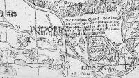
The article focused on research of cartographic sources of the “Kniga Bolshomu Chertegu” that was made in 30th of the XX century by F.Petrun. In his opinion, the source of the description of Ukraine in the “Kniga Bolshomu Chertegu” was the map by V. Grodetsky, 1595, that was the part of the atlas by A. Ortelius Theatrum Orbis Terrarum. On many European maps from the mid XVI century the town marked Szinouoda, Swiniovoda on the same river was indicated. F.Petrun created the “genealogy” of images of Ukraine on European maps of XVI century. The starting point, the initial map of this genealogy, is the map of South Sarmatia by Polish cartographer B. Wapowski, 1526. A fragment of it is on the picture (Fig.1).
On this map at first time the Sinjuha river (Syinauoda fl) and buildins (or ruins) near it’s confluence to the Southern Bug river were indicated. Description of stone ruins (named Dolnia Horofossa) near the confluence of this two rivers contains in Tartariae Descriptio by M.Bronevski, created 50 years after the map of the South Sarmatia. G.Mercator on his map of Europe, 1554, used Wapowski’s map, but turned the nameless buildings into the city Szinouoda on the right bank of the Sinjuha river. This mapping error was repeated on many later maps, and got from them to the “Kniga Bolshomu Chertegu”.
Based on these arguments, the author concludes that the “town Sinya Voda” on Sinjuha river was “created” by G.Mercator on his map of Europe, 1554, but real settlement or fort of such a name does never existed.

